image_pdfimage_print

Vradeto – Beloi

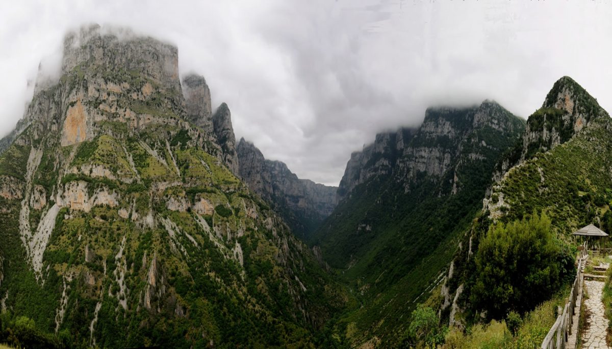
Starting point: Vradeto. End: “Beloi” view point. Trail distance: 2 km. Duration: 30 minutes. Altitude scale: 1.340 m. – 1.450 m. Route type: path. Signage: rough. Degree of difficulty: low. Points of interest: the panoramic view of the Vikos Gorge. 0 CommentsΤα σχόλια είναι κλειστά!

Read More

Kapesovo – GradisTa – Kapesovo

Starting point: Kapesovo. End: Kapesovo. Trail distance: 3 km. Duration: 2 hours and 30 minutes. Altitude scale: 1.100 m. – 1.300 m. – 1.100 m. Route type: path. Signage: rough. Points of interest: the sacred woods of Lower Gradista, the view of the Vikos Gorge, the church of Taxiarhes, the Paschaleios School in Kapesovo, the […]

Read More

Bridge of Papigo – Voidomatis Bridge in Klidonia

Starting Point: Bridge of Papigo. End: Voidomatis Bridge at Klidonia. Trail distance: 4 km. Duration: 2 hours and 30 minutes. Altitude scale: 480 m. – 430 m. Route type: path. Signage: rough. Degree of difficulty: medium. Points of interest: the river Voidomatis and the homonymous canyon, the Monastery of Panagia Spiliotissa (1665), the church of […]

Read More

Monodendri – Vikos (or Papigo)

Starting point: Monodendri. End: Vikos (or Papingo). Trail distance: 10 km. Duration: 6 hours. Altitude scale: 1.060 m. – 770 m. Route type: path. Special signage: O3. Signage: good. Degree of difficulty: high. Points of interest: the Rizarios Handicraft Centre and the Rizarios Exhibition Centre in Monodendri, the Vikos Gorge, the geological formations, the springs […]

Read More

Iliohori – Waterfalls of Iliohori

Starting point: Iliohori. End: Waterfalls of Iliohori. Trail distance: 1 km. Duration: 1 hour. Altitude scale: 950 m. – 790 m. Route type: path. Signage: good. Degree of difficulty: medium. Points of interest: the waterfalls, the view of Timfi, the huge plane tree in Iliohori village. 0 CommentsΤα σχόλια είναι κλειστά!

Read More

Negades – Tsepelovo

Starting point: Negades. End: Tsepelovo. Trail distance: 7 km. Duration: 3 hours and 15 minutes. Altitude scale: 1.060 m. – 1.080 m. Type of route: trail (forest road in some parts). Signage: rough. Degree of difficulty: medium. Points of interest: the church of Agia Triada – Agios Dimitrios – Agios Georgios (1795) in Negades village, […]

Read More

Kapesovo- Vradeto’s Skala

(STONE steps) – Vradeto Starting point: Kapesovo. End: Vradeto. Trail distance: 3 km. Duration: 1 hour and 45 minutes. Altitude scale: 1.100 m. – 1.340 m. Route type: path. Signage: medium. Degree of difficulty: low. Points of interest: the Stone steps “Skala Vradetou”, the Mezaria bridges, the Mezaria gorge, the Paschaleios School of Kapesovo.   […]

Read More

Kipi-Koukouli

Starting point: Kipi. End: Koukouli. Trail distance: 2,5 km. Duration: 45 minutes. Altitude scale: 800 m. – 900 m. Route type: path. Signage: good. Degree of difficulty: low. Points of interest: Lazaridis or Kontodimos bridge (1753) and the ruins of Lazaridis mill, the Botanical museum of Koukouli, the churches and the mansions of both villages, […]

Read More

Dilofo – Kipi

Starting point: Dilofo. End: Kipi. Trail distance: 4 km. Duration: 1 hour and 30 minutes. Altitude scale: 880 m. – 800 m. Route type: path. Signage: rough. Degree of difficulty: low. Points of interest: the Captain Arkouda’s bridge, the three arched Plakida’s or Kalogeriko bridge (1814), Lazaridis or Kontodimos bridge (1753), the churches and mansions […]

Read More

Vitsa – Skala (Stone steps) of Vitsa – Noutsos/ Kokkoris Bridge

Starting point: Vitsa. End: Noutsos/Kokkoris Bridge. Trail distance: 3 km. Duration: 1 hour and 30 minutes. Altitude scale: 960 m. – 700 m. Route type: path. Signage: medium. Degree of difficulty: low. Points of interest: churches and mansions in Vitsa, the stone steps of Vitsa, the bridges of Missios (1748) and Noutsos / Kokkoris  (1750), […]

Read More