image_pdfimage_print

Konitsa – Vrisohori

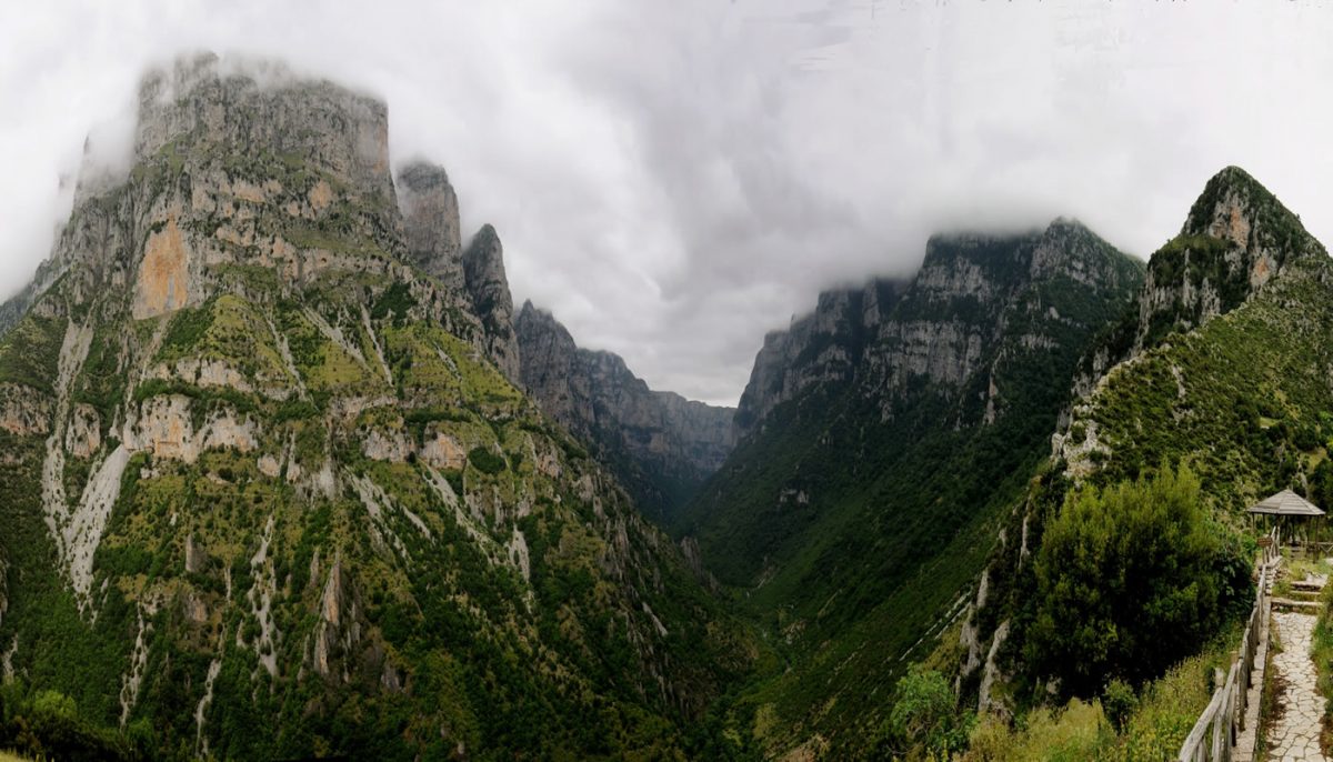
Starting Point: Konitsa bridge. End: Vrisohori. Trail distance: 14 km. Duration: 12 hours. Altitude scale: 450 m. – 900 m. Route type: at the beginning forest path and then path. Signage: rough. Degree of difficulty: very high. Points of interest: Aoos gorge, Konitsa bridge (1870), Stomio Monastery (1774), mansions in upper town of Konitsa, churches […]

Read More

Konitsa bridge – Stomio Monastery

Starting Point: Konitsa bridge. End: Holy Monastery of Stomio which is dedicated to Panagia (Virgin Mary). Trail distance: 6 km. Duration: 2 hours. Altitude scale: 450 m. – 800 m. Route type: Forest path, path. Signage: good. Degree of difficulty: medium. Points of interest: Konitsa bridge (1870), Stomio Monastery (1774), the view to the Aoos […]

Read More

Konitsa-Aoos gorge-Drakolimni (Dragon Lake) of Timfi

Starting Point: Konitsa bridge. End: Drakolimni of Timfi. Trail distance: 12 km. Duration: 7 hours and 30 minutes. Altitude scale: 450 m. – 2.100 m. Route type: at the beginning forest path and then path. Signage: good. Degree of difficulty: high. Points of interest: Aoos gorge, Drakolimni of Timfi, Konitsa bridge (1870), Stomio Monastery (1774), […]

Read More

Tsepelovo-Drakolimni (Dragon Lake) of Timfi

Starting point: Tsepelovo. End: Drakolimni of Timfi. Trail distance: 14 km. Duration: 6 hours and 30 minutes. Altitude scale: 1.080 m. – 1.950 m. – 1.750 m. – 2.100 m. Route type: path. Signage: rough. Degree of difficulty: high. Points of interest: the subalpine plateaus, subalpine lakes, rockycliffs, ravines. Remark: Along the route one can […]

Read More

Vikaki gorge (Selato) – Holy monastery of Ioannis Rogovos

Starting point: “Manetes” location, 3 km after the village of Kapesovo to Tsepelovo on the main road. End: Holy monastery of Ioannis Rogkovos. Trail distance: 2 km. Duration: 2 hours. Altitude scale: 1.070 m. – 800 m. – 990 m. Route type: path. Signage: rough. Degree of difficulty: medium. Points of interest: The Monastery of […]

Read More

Megalo Papigo – Ano Klidonia

Starting point: Megalo Papigo. End: Ano Klidonia. Trail distance: 4,5 km. Duration: 2 hours. Altitude scale: 1.050 m. – 900 m. Route type: path. Signage: medium. Degree of difficulty: medium. Points of interest: the view of the Vikos gorge and Astraka (Papigo) towers, the mansions and old churches in Papigo, the old churches in Klidonia. […]

Read More

Mikro Papigo-Astraka

Starting point: Mikro Papigo. End: Astraka peak. Trail distance: 5 km. Duration: 5 hours and 30 minutes. Altitude scale: 1.050 m. – 2.436 m. Route type: path. Signage: good. Degree of difficulty: high. Points of interest: the Northern Pindos National Park Information Center in Papigo, the subalpine landscape and plateaus, the high rocky cliffs, the […]

Read More

Mikro Papigo- Gamila

Starting point: Mikro Papigo. End: Gamila peak. Trail distance: 10 km. Duration: 7 hours. Altitude scale: 1.050 m. – 2.497 m. Route type: path. Signage: good. Degree of difficulty: high. Points of interest: the Northern Pindos National Park Information Center in Papigo, the subalpine landscape and plateaus, the high rocky cliffs.   0 CommentsΤα σχόλια […]

Read More

Mikro Papigo-Drakolimni of Timfi (Dragon Lake)

Starting point: Mikro Papigo. End: Drakolimni. Trail distance: 8 km. Duration: 4 hours and 30 minutes. Altitude scale: 1.050 m. – 2.100 m. Route type: path. Signage: good. Degree of difficulty: high. Points of interest: the Northern Pindos National Park Information Center, the subalpine lakes and plateaus, the rocky cliffs. 0 CommentsΤα σχόλια είναι κλειστά!

Read More

Vradeto – Drakolimni

  (Dragon Lake) of Timfi Starting point: Vradeto. End: Drakolimni of Timfi. Trail distance: 16 km. Duration: 6 hours and 45 minutes. Altitude scale: 1.340 m. – 2.100 m. Route type: path. Signage: rough. Degree of difficulty: high. Points of interest: Loutsa Rambozi, Xerolimni, Drakolimni of Timfi, the view to Gamila peak and Aoos valley. […]

Read More