

Listing and description of the geological sites present on the territory of the Geopark
A great number of geological sites are present within the area of the Geopark, which are being assessed and catalogued by the Institute of Geology and Mineral Exploration (IGME). The main geological sites of the Vikos-Aoos area are listed on below.
Geosites of Vikos – Aoos Global Geopark
| No | Geosite |
| 1 | Compression structures |
| 2 | Drakolimni |
| 3 | Kolimvithres (ovires) (stone baths) |
| 4 | Precipices |
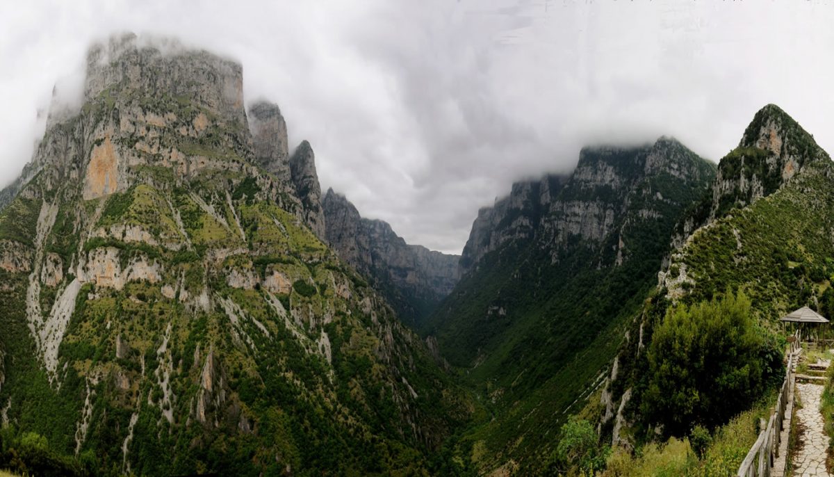
| 5 | Panorama of Vikos gorge |
| 6 | Petrino dasos |
| 7 | Theoktista (Tower-like plaques of limestones) |
| 8 | Voidomatis river springs |
| 9 | Mana nerou spring |
| 10 | Konitsa fault |
| 11 | Kleidi rock shelter |
| 12 | Glacial deposits at Tsepelovo |
| 13 | Karstic plain (Vradeto) |
| 14 | Panorama of Aoos gorge |
| 15 | Boila rock shelter |
| 16 | Arapis spring |
| 17 | Karstic plain (Stouros) |
| 18 | Kapesovo fault |
| 19 | Beloi (Panorama of Vikos gorge) |
| 20 | Tripa tis Grias (precipice) |
| 21 | Panorama of Vikaki |
| 22 | Tsepelovo fault |
| 23 | Vikaki Gate (Hatsiou bridge) |
| 24 | River terrace |
| 25 | Stone tower near at Kokkorou Bridge |
| 26 | Synsedimentary folds |
| 27 | Rock shelter |
| 28 | Klima spring |
| 19 | River terrace with Rock shelter |
| 30 | Observation point (Station) |
| 31 | Gastromeni spring |
| 32 | Panorama of Vikos gorge from Vikos village |
| 33 | Panorama of Astraka fault |
| 34 | Oikonomou springs |
| 35 | Sousta spring |
| 36 | Provatina precipice |
| 37 | Glacial rocks at Astraka |
| 38 | Panorama of Konitsa (Konitsa tour Start point) |
| 39 | Neles spring |
| 40 | Aoos exit – Konitsa fault |
| 41 | Kavasila Spa |
| 42 | Bourazani – Aoos river terrace |
- Geosites 1: Characteristic compression structures with nicely formed folds of the Ioanian limestones and normal faults due to the neotectonic activity are located in the area where the Pindos zone overthrust on the Ionian zone.
- Geosite 2: Drakolimni is a formation which was created after the retreat of the glaciers.
- Geosite 3: Kolimvithres or Ovires are natural pools, exquisite and renowned forms of erosion on the bed of Rogovo stream, which have been traced on the horizontal layers of the thin-bedded limestones.
- Geosite 4: The impressive precipices are the result of the perpendicular karsting of limestones and of the presence of faults. The precipices are being studied and explored by caving enthusiasts because they are unique and very deep.
- Geosite 5: Panorama of Vikos gorge near the area of Monodendri village, where it is its narrowest point. The panoramic view from a small platform at Oxia is simply awesome. It is a brand new experience that allows the visitor to enjoy the geological history of the area unfolding right before their eyes. At this site limestones date back to 35 million years ago and at the base of the gorge limestones date back to 160 million years ago.
- Geosite 6: Petrino dasos is an area of impressively developed karstic field at an altitude of 1,500 meters. Stone columns intertwined with vegetation, a “stone forest” is competing with the oak and maple forest. Thin layers of Eocene limestone are carved by water and the wind, having as guides the cracks opened by the rectangular fault system.
- Geosite 7: Theoktista are plaques of limestones which rise up abruptly, forming tower-like shapes. The holes in the limestones are remnants of old karstic ducts. The tower-like structures, like remnants of gigantic structures scattered in the area, even more impressive; they are due to the perpendicular erosion of the river.
- Geosite 8: The main springs feeding Voidomatis river (Oikonomou springs). The geological processes at this site have brought the underground ducts to the surface. Rainwater and water from melting snow flow within the cracks of the limestones on the Tymfi mountain range, through a complicated duct network. Large faults, such as Astraka fault, contribute to the creation of privileged flows into large ducts, which were exposed when Voidomatis eroded deeply the limestones. The water is abundant and the mean discharge of the spring is 1.53 m3/sec, while the mean water temperature is 9°C without important seasonal variations.
- Geosite 9: Mana nerou spring, which with its silent emanation of water adds allure to the magical environment.
- Geosite 10: Konitsa fault belongs to an area with spectacular neotectonic variations. The main geological structure is the Konitsa fault, which is responsible for the great regression of the relief. This fault was activated by the powerful 1996 earthquake, which caused extensive damages at Konitsa. The marking of the fault is clear and it can be identified by the sudden change in morphology, from the high-rising relief of Tymfi to the low-standing relief of Konitsa basin. The fault stretches for 25 km; its direction is NE-SW and its heave reaches 1,000 m. On the descending segment of the fault, there is a lateral scree and talus cones dating back to the Pleistocene. The two big rivers, Aoos and Voidomatis, followed this evolution throughout. At their outlet, they intersect Konitsa fault perpendicularly and they form river terraces from limestone pebbles and sand. The outlet of Voidomatis is V-shaped, a representative type of intense perpendicular erosion.
- Geosite 11: Kleidi rock shelter is a site that used to be inhabited by human beings during the Upper Paleolithic period; archaeological excavations testify to the fact that the site was used 16,000-13,000 years BP.
- Geosite 12: Glacial rock at Tsepelovo. The geosites includes remnants of the last ice age. It contains sands, gravels and large limestone blocks with rounded surfaces.
- Geosite 13: The karstic plain at Vradeto village, a landscape developing on the limestones. Rectangular cutting of the limestones is observed, due to the action of water on the traces of the joints.
- Geosite 14: A spectacular panorama of the Aoos
- Geosite 15: Boila rock shelter is at the entrance of the gorge, 50 m away from the Southern end of the bridge; the shelter is an important geoarchaeological site. Boila rock shelter used to be inhabited 14,000 years ago. That was due to the abundance of water, from the river and the springs; what is more, the rock shelters became a natural shelter and provided a safe spot for prehistorical human beings.
- Geosite 16: Arapis spring, one of the most valued springs of the study area.
- Geosite 17: The karstic plain at Stouros, a landscape developing on the limestones. Rectangular cutting of the limestones is observed, due to the action of water on the traces of the joints.
- Geosites 18: Deep grooves caused by the streams on the limestones, evidence of very rapid erosion. The stream Mezaria flows on the zone of the Kapesovo fault. The limestones seen on the way up Vradeto village stairs, date back to 55-35 million years ago (Eocene).
- Geosite 19: At Beloi, the majestic panoramic view of the geological forms created by the perpendicular erosion of Voidomatis, is enjoyed.
- Geosite 20: At the beginning of the route to Beloi, we come across Tripa tis Grias, a precipice formed by limestones, due to the water’s erosive processes.
- Geosite 21: The gorge Vikaki is an impressive miniature of Vikos gorge.
- Geosite 22: Tsepelovo fault is a dominant tectonic structure with high vertical leap, which contributed to morphological evolution of the region.
- Geosite 23: Vikaki gate is an area with intense vertical erosion of limestone, near Hatsiou bridge.
- Geosite 24: At the outlet of the two big rivers, Aoos and Voidomatis, they intersect Konitsa fault perpendicularly and form river terraces from limestone pebbles and sand. The outlet of Voidomatis is V-shaped, a representative type of intense perpendicular erosion.
- Geosite 25: The impressive stone three-arch Bridge Kokkorou, is located a few dozen meters westwards of Theoktista, along the road.
- Geosite 26: Near the river bed characteristic structures, such as black chert lenses, breccias and synsedimentary folds, can be distinguished. Limestones date back to the Cretaceous (140-60 million years ago).
- Geosite 27: Rock shelter that was formed at the recesses of the limestones and the cohesive side scree, the petrological steps that have been created on perpendicular slopes due to the differentiation of limestones in the perpendicular erosion of the river, and the faults cutting the limestones.
- Geosite 28: Klima spring, one of the most valued springs of the study area.
- Geosite 29: River terrace with Rock shelter, an impressive terrace of Aoos, along the rock shelter.
- Geosite 30: One of the places of observation of individual components making grandiose Vikos gorge. Apart from the aesthetic dimension, the effects of physical processes that shaped the area can be distinguished.
- Geosites 31: Gastromeni (pregnant) spring and Oikonomou spring (Geosites 34) discharge the Tymfi karstic system. The mechanism of the discharge is complex, and the lake’s appearance is a result of the aquifer section from Voidomatis river. At the point where the spring issues, there are faults belonging to the Astraka fault zone. Gastromeni spring is a faulted, contact spring of variable issue (with water emanating at intervals). Its name (Gastromeni means pregnant) is due to this characteristic.
- Geosite 32: Panorama of Vikos gorge near its end, at the village Vikos.
- Geosite 33: Panorama of Astraka fault.
- Geosite 35: Sousta spring, one more valued spring of the study area.
- Geosite 36: Provatina precipice is 408 m deep, one of the biggest perpendicular precipices worldwide. At 180 m deep, there is ice that never melts. The precipice was first located by English speleologists, in 1965 (Cambridge University Caving Club). Ever since then, a large number of Greek and even more foreign expeditions visit the majestic precipice every year.
- Geosite 37: Glacial rocks at Astraka.
- Geosite 38: A clear and informative Panorama of Konitsa, at the Konitsa tour start point.
- Geosite 39: At Kleidonia village, there is Neles spring, a hydrogen sulphide warm thermal spring, emanating at the base of Konitsa fault.
- Geosite 40: Aoos exit and Konitsa fault, near the town of Konitsa.
- Geosite 41: An important spa area at the village of Kavasila.
- Geosite 421: The Aoos river terrace at the village of Bourazani.
Τα σχόλια είναι κλειστά!