

A world beneath the earth: Caves and Caving
Manolis Diamantopoulos, Speleologist – Guide of Outdoor Activities
Caves are subterranean formations which are developed vertically or horizontally beneath the earth’s surface, often extending deep underground.
The first distinctive feature of their morphology is the opening in the surface of the earth which constitutes their entry point and can vary from a few centimeters to tens of meters and there are caves which have more than one entry.
Caves develop as wells of various sizes and shapes. Apart from the form of vertical wells, caves consist also of big or small cavernous halls, galleries, narrow or spacious meanders, underground rivers, waterfalls, lakes as well as various cave formations such as stalactites, stalagmites, stone basins, stalagmite columns etc.
The creation of caves and potholes is a special karstification phenomenon, called underground karst. The main factors that define a karstified area are water, geological substrate (type of rock) and geomorphology due to the area’s tectonics (faults and fractures).
The most important and largest caves are created where the geological substrate is composed mainly of carbonate rocks, i.e. limestone with main ingredient calcium carbonate (CaCo3) and water soluble dolomite [limestone with magnesium (Mg)].
During speleogenesis phase water penetrates the rock’s crevices and fractures (cracks) and erodes it weathering the limestone both chemically and mechanically.
Caves and potholes are found throughout world due to the existence of limestone and other karstification factors. The largest and longest caves, whose route length is more than 6 km, are located in three countries: USA with 176 caves, France with 103 and Italy with 37 caves.
The potholes of the Vikos-Aoos Geopark
Timfi and the adjacent Stouros mountain are karstified areas and so far speleological explorations have revealed more than 300 caves and potholes, classifying them as very important areas nationally and globally in terms of speleological interest. The greatest part and the larger potholes are located in Astraka plataeu, where the deepest one is “Tripa tou Orinou”.
One of the distinctive features of the area’s potholes is their high verticality with large single integral shafts and small horizontal development in relation to their depth.
Other features are the absence of water on a permanent basis, such as waterfalls or underground rivers, while in a few cases there are small ponds at their bottom or water drops from snow or ice melting.
The top eight out of the 300 vertical caves (potholes) found in the Geopark
- “Tripa tou Orniou” (depth 584m / 650m length): Terraced pothole consisting of many large and small vertical shafts, the deepest of which reaches 90m.
- “Chasma tou Epous” (depth 455m): Huge pothole with large double entrance. It consists of three large vertical shafts, the deepest of which reaches 180m while on its bottom there is water.
- “Provatina” (depth 407m) is an almost single shaft, which consists of two sections of a total depth of 180m and 220m respectively.
- “Tripa tis Ligeris” (depth 386m / 591m length) has two adjacent entrances. It is one of the few potholes of the area with many small “descents” up to 50m.
- “Tripa tis Niphis” (depth 285m): It consists of three shafts, the largest of which reaches 185m in depth.
- “Spiara Tsepelovou” (228m depth.): It is almost a single pothole with four levels in various points.
- “Tripa tou Kati” (depth 200m): It consists of two vertical shafts, the deepest of which reaches 110m.
- “Chionotripa” (depth 152m): It consists of many small “descents” (max. 20m depth). Vradeto inhabitants used to collect ice from this cave.
The history of caving in the Geopark
Caving is an outdoor activity that combines the exploration, mapping, photographing as well as at the scientific study of caves. The speleological explorations in the Vikos-Aoos Geopark started in the early 60s. British cavers from the University of Cambridge, were the first who reached Astraka area in 1962 and identified the entrance of Provatina pothole (-405m). The exploration of Provatina pothole started in 1996 by a British mission and completed in 1968, when the British military mission arrived first at the bottom using a winch with wire rope at the edge of which there was a basket. The Chasma tou Epous pothole (-455m) was firstly explored by an English mission in 1968-1969. The “Tripa tis Niphis” pothole (-285 m) was explored gradually over the period 1969 – 1977 by two English, an American and an Australian mission.
Since the 70s there have been dozens of exploring missions in Timfi’s caves and potholes by speleologists of various countries. In 1970-1990 most missions aimed at descending the deepest known potholes in the world, which at that time were: “Provatina” and “Chasma tou Epous” potholes on the Astraka plateau.
The first Greek mission in these two large potholes has taken place in 1978 by the Hellenic Speleological Society while during the next years various members of this Society and other speleological clubs, SPELEO (Hellenic Speleological & Exploration Club) and SELAS (Hellenic Speleological Athletic Club) conducted also additional explorations in these potholes. Finally missions of Italian speleologists from Trieste (San Giousto Triestino) and Rome (SCR: Speleo Club Roma) have highly contributed to the promotion of caving through their explorations mainly in the areas of Stouros mountain and Vradeto village.


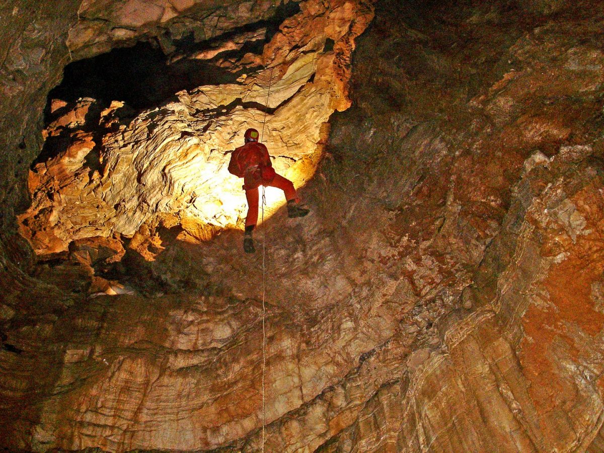
 1024 Σπηλαιολόγος σε βάραθρο 1023 Έρευνα πεδίου για τον εντοπισμό σπηλαιοβαράθρων. - ΜΑΝΩΛΗΣ ΔΙΑΜΑΝΤΟΠΟΥΛΟΣ/ MANOLIS DIAMANTOPOULOS")
 1024 Σπηλαιολόγος σε βάραθρο 1023 Έρευνα πεδίου για τον εντοπισμό σπηλαιοβαράθρων. - ΜΑΝΩΛΗΣ ΔΙΑΜΑΝΤΟΠΟΥΛΟΣ/ MANOLIS DIAMANTOPOULOS")
 1024 Σπηλαιολόγος σε βάραθρο 1023 Έρευνα πεδίου για τον εντοπισμό σπηλαιοβαράθρων. - ΜΑΝΩΛΗΣ ΔΙΑΜΑΝΤΟΠΟΥΛΟΣ/ MANOLIS DIAMANTOPOULOS")
")
")
 1024 Σπηλαιολόγος σε βάραθρο 1023 Έρευνα πεδίου για τον εντοπισμό σπηλαιοβαράθρων. - ΜΑΝΩΛΗΣ ΔΙΑΜΑΝΤΟΠΟΥΛΟΣ/ MANOLIS DIAMANTOPOULOS")
")
")
")
Τα σχόλια είναι κλειστά!